Madrid Barajas Airport (MAD)
City Orientation and Maps
(Madrid, Spain)
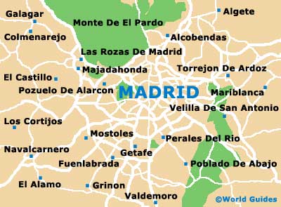
The city of Madrid, Spain's famous capital, is vast and always busy. Located in central Spain, Madrid is close to a number of notable cities, towns and villages, which are often just a short drive away, being located in or nearby the greater autonomous Comumidid de Madrid area.
Highlights include Ávila, El Pardo, Guadarrama and Segovia to the north-west, Alcobendas and Colmenar Viejo to the north, and Aranjuez directly south. Also worth noting, Arganda del Rey, Chinchón and El Escorial can all be found to the south-east of Madrid, while Alcalá de Henares lies to the east, just a few miles from Madrid Barajas International Airport (MAD).
Madrid Barajas International Airport (MAD) Maps: Important City Districts
Madrid can be reached from all over Spain and many major roads and highways lead both to and from the city. The main roads radiating outwards from the centre of Madrid include the Calle de Alcalá, the Calle del Arenal, the Calle Mayor, the Calle de la Montera and the Calle Preciados.
The Puerto del Sol is the physical centre of Madrid and is sited slightly north-east of the famous Plaza Mayor, one of the most historic areas of the city. To the south-east of the Puerto del Sol you will find the Huertas district, a particularly busy area full of shops, restaurants and Tapas bars. Located on the northern side of central Madrid is a large and modern shopping district, with the Gran Via sited nearby - a prominent artery running in an easterly / westerly direction. In the eastern region of Madrid, the majestic Palacio Real is worthy of a visit, while the spreading El Retiro parkland lies on the opposite side.
Spain Map

Madrid Map